
Six major non US satellite markets are building sovereign systems for connectivity navigation Earth observation and defence
Introduction
There are now many thousands of active satellites circling Earth, accompanied by spent rocket stages, defunct spacecraft and fragments of debris. The precise total depends on whether one counts active payloads, inactive objects or everything tracked in orbit. What is not in doubt is that the United States, led by the extraordinary expansion of Starlink, accounts for the largest share of operational satellites. That dominance can make the rest of the market look smaller and quieter than it really is.
China, Russia, India, Brazil, Japan and South Korea are all developing satellite capabilities that reflect their geography, security priorities and industrial ambitions. Some are building low Earth orbit broadband constellations. Others are concentrating on sovereign communications, positioning, Earth observation, weather monitoring or military resilience. Together they form six major non US satellite markets with growing influence over the space services available to governments, companies and citizens.
For maritime users, this is not an abstract space race. Satellites support communications at sea, precise positioning and timing, weather forecasting, sea ice monitoring, fisheries management, environmental surveillance and search and rescue. They also underpin naval operations and provide governments with an increasingly detailed view of shipping activity. The important questions are therefore not simply how many satellites each country has, but what those systems do, who can use them, how commercially accessible they are and what they mean for vessels operating in their regions.
China
China has developed the broadest and most ambitious satellite ecosystem of the six markets. Its portfolio spans broadband communications, navigation, Earth observation, weather monitoring, reconnaissance and a permanently crewed space station. The country is now moving from individual programmes towards industrial scale constellations and mass production.
What China operates
The two most closely watched broadband projects are Guowang and Qianfan. Guowang is controlled by the state owned China Satellite Network Group and is intended to provide sovereign communications capacity for government, national infrastructure and commercial users. Qianfan, also marketed internationally as SpaceSail, is backed by Shanghai interests and is intended to become a global commercial broadband network. The first Qianfan deployment took place in August 2024. By September 2026, live orbital tracking indicated that Guowang and Qianfan each had more than 180 and 230 satellites in orbit respectively, although both remain far short of their planned scale.
China also operates BeiDou, its global positioning, navigation and timing system. BeiDou is already mature and provides an alternative to GPS, Galileo and GLONASS. The Yaogan and Gaofen families supply optical and radar Earth observation, while the Haiyang series observes oceans and coastal environments. These systems sit alongside meteorological satellites and communications capacity operated by China Satcom.
What it means for maritime
BeiDou is the most immediately relevant Chinese system for commercial shipping. Compatible receivers can use its signals for navigation and timing, and its short message capability has particular value where terrestrial communications are unavailable. Chinese Earth observation satellites can support ocean monitoring, weather assessment, fisheries management and maritime domain awareness.
Qianfan is potentially more disruptive. SpaceSail has international ambitions and has begun discussing services and partnerships beyond China, including markets where the regulatory position of Western networks is politically sensitive. It is not yet a mature substitute for Starlink at sea, but it could develop into a state backed alternative for Chinese fleets, Belt and Road partners and governments seeking more control over their communications infrastructure.
Russia
Russia was once at the centre of the global space race. It launched Sputnik 1 in 1957, sent Yuri Gagarin into orbit in 1961 and built some of the earliest satellite broadcasting and space station systems. Its recent record has been more uneven. Ageing spacecraft, constrained access to Western components and limited launch and manufacturing capacity have slowed renewal, while decades of Soviet and Russian activity have contributed materially to the debris population in orbit.
What Russia operates
GLONASS is Russia’s global navigation system and remains its most important operational constellation. It provides positioning and timing around the world, but the system faces a continuing requirement to replace ageing satellites. The Russian Satellite Communications Company operates the Express family of geostationary communications satellites, while Gazprom Space Systems operates the Yamal fleet. These networks provide television, government and commercial communications across Russia and neighbouring regions.
Russia is also developing Rassvet through Bureau 1440. Experimental spacecraft were launched before the first larger operational batch in 2026. Further deployments followed during the year, but the constellation remains at an early stage and does not yet offer the continuous global service associated with Starlink. Its intended customers include government bodies, large companies, transport networks and users in remote northern territory.
What it means for maritime
Russia’s satellite priorities are closely tied to sovereignty, defence and the enormous distances of the Arctic. GLONASS remains available to compatible maritime receivers, and Express and Yamal capacity supports communications in Russian waters. Rassvet could eventually improve low latency broadband across the Northern Sea Route, but commercial availability, terminal supply and international access remain uncertain.
Russia therefore offers a useful reminder that orbital ambition does not automatically create a commercially accessible maritime service. International shipping companies must consider sanctions, equipment support, regulatory exposure and continuity of service as carefully as technical coverage.
India
India’s space programme combines a long established state sector with a rapidly growing commercial industry. The country launched its first satellite, Aryabhata, in 1975 and demonstrated an independent orbital launch capability with Rohini in 1980. Policy reforms have since opened more of the market to private businesses such as Dhruva Space, Pixxel, Skyroot Aerospace and Agnikul Cosmos.
What India operates
India’s communications capacity is delivered through the INSAT and GSAT families, which support telecommunications, broadcasting, meteorology, disaster warning and search and rescue. NavIC is India’s independent regional navigation system. It uses a mixture of geostationary and inclined geosynchronous satellites to provide positioning and timing across India and approximately 1,500 kilometres beyond its borders.
The country also has a substantial Earth observation portfolio. Resourcesat supports land monitoring, Cartosat provides mapping imagery, RISAT uses radar observation and the Oceansat series measures ocean colour, winds and other marine conditions. This makes India notable not simply for communications, but for the integration of navigation, weather and ocean data.
What it means for maritime
NavIC has direct relevance to vessels operating around India and across the northern Indian Ocean, particularly as compatible receivers become more widely available. INSAT supports distress alert and search and rescue functions, while Oceansat data contributes to weather analysis, fisheries, cyclone monitoring and understanding marine productivity.
Most Indian systems were designed primarily for national or regional requirements rather than global retail connectivity. The commercial opportunity lies in applications, data services, terminals and future privately operated constellations. India may therefore become as important as a supplier of maritime information and technology as it is as an operator of satellites.
Brazil
Brazil’s satellite strategy reflects the scale of the Amazon, the remoteness of many communities and the need to protect a vast coastline and exclusive economic zone. It combines sovereign communications, Earth observation, international partnerships and the use of foreign commercial constellations.
What Brazil operates
Amazônia 1, launched in 2021, was the first Earth observation satellite fully designed, integrated, tested and operated by Brazil. It supports monitoring of deforestation and agriculture. Brazil also participates with China in the long running China Brazil Earth Resources Satellite programme. CBERS imagery is used for vegetation, land use, water management and environmental monitoring.
The Geostationary Defence and Strategic Communications Satellite, or SGDC, was launched in 2017. It provides secure government and military communications as well as civil broadband coverage. Brazil nevertheless remains dependent on foreign launch services. Its domestic orbital launch record has been less than spiffing: the country has built valuable infrastructure at Alcântara, but has yet to establish a reliable indigenous orbital launch capability.
What it means for maritime
Brazilian Earth observation data is valuable for coastal surveillance, environmental protection and monitoring activities around ports, rivers and offshore energy infrastructure. SGDC strengthens sovereign communications, but it is not positioned as a global maritime retail service. Commercial users are more likely to encounter a mixed market involving domestic integrators, international GEO operators and Starlink.
Brazil is therefore best viewed as an important regional user and integrator of satellite services. Its maritime significance comes from the size of its coastline, offshore energy sector, fisheries and trade flows rather than from a direct challenge to the largest global satellite operators.
Japan
Japan became the fourth country to place a satellite into orbit using its own launch vehicle when it launched Ohsumi in 1970. It has since developed sophisticated capabilities in navigation, Earth observation, meteorology, communications, launch services and debris inspection.
What Japan operates
The Quasi Zenith Satellite System, known as Michibiki, augments GPS over Japan and the wider Asia Pacific region. The system is expanding from four to seven satellites as Japan works towards a more independent positioning capability. The Himawari meteorological satellites provide high frequency weather observations, while ALOS 4 carries L band synthetic aperture radar for detailed Earth observation in darkness and through cloud.
Japan also has a mature commercial satellite sector. SKY Perfect JSAT operates geostationary communications capacity, while Mitsubishi Electric is a major satellite manufacturer. Astroscale has demonstrated rendezvous and proximity operations around a spent Japanese rocket stage through ADRAS J, an important step towards future debris inspection and removal services.
What it means for maritime
Japan’s greatest maritime value lies in the combination of positioning, weather intelligence, radar imaging and commercial communications. QZSS can improve positioning availability and accuracy in the region. Himawari supports typhoon monitoring, and ALOS radar data can contribute to disaster response, coastal monitoring and observation of vessels or infrastructure.
Unlike some of the other markets examined here, Japan has an established commercial supply chain and close relationships with Western partners. Its systems are consequently more accessible to international users, although QZSS remains regionally focused and is an augmentation service rather than a direct replacement for every GPS function.
South Korea
South Korea is building a broader space capability around Earth observation, communications, national security and domestic manufacturing. Its market remains smaller than those of China, India or Japan, but it benefits from a strong electronics industry and an increasingly active group of commercial satellite companies.
What South Korea operates
The KOMPSAT series, also known as Arirang, consists of Earth observation satellites rather than a communications constellation. It combines optical and radar imaging for mapping, environmental monitoring and disaster response. GEO KOMPSAT 2A and 2B provide meteorological, environmental and ocean observations from geostationary orbit.
The KOREASAT family supplies commercial geostationary communications, while ANASIS II provides dedicated military communications. The NEONSAT programme is intended to become a small Earth observation constellation. NEONSAT 1 entered orbit in 2024, followed by NEONSAT 1A in 2025, with additional satellites planned for 2026 and 2027. Satrec Initiative is also developing private high resolution imaging capacity through SpaceEye T.
What it means for maritime
South Korea’s immediate maritime strengths are observation and regional communications rather than global broadband. GEO KOMPSAT 2B carries an ocean colour instrument that observes waters around the Korean Peninsula and supports monitoring of marine ecosystems, pollution and coastal conditions. Radar and optical imagery can also support disaster response and maritime surveillance.
Commercial access varies by system. KOREASAT capacity is available through established communications channels, while government observation data and emerging private imagery services offer opportunities for maritime analytics. South Korea is unlikely to challenge Starlink directly in the near term, but it could become an important provider of regional data, payloads and satellite manufacturing.
Six markets compared
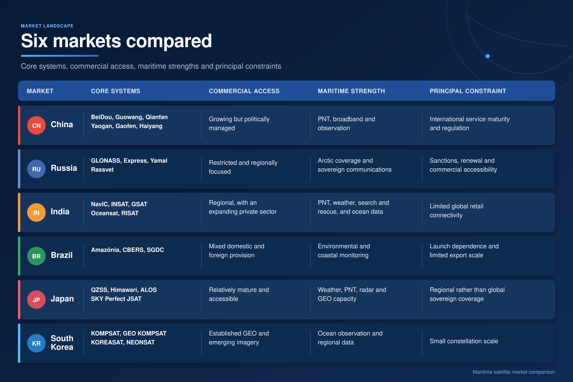 A more fragmented maritime satellite market
These six markets are not producing six equivalent versions of Starlink. Their systems reflect different national priorities. China is assembling the most credible alternative broadband ecosystem. Russia is pursuing communications sovereignty and Arctic coverage under significant industrial constraints. India combines regional navigation with weather and ocean observation. Brazil uses space infrastructure to connect and monitor a huge national territory. Japan brings together mature commercial communications and advanced observation. South Korea is developing a technically capable regional data and manufacturing base.
For shipowners and service providers, this creates opportunity but also complexity. More satellite systems can improve resilience and reduce dependence on a single provider. Additional positioning signals can strengthen navigation, while new radar, optical and weather data can improve routing, safety and maritime domain awareness. Yet technical availability is only part of the calculation. Terminals must be approved, services must be licensed, data must be trusted and support must be available when a vessel is thousands of miles from shore.
The market is also becoming more political. Satellite networks are strategic infrastructure, and governments increasingly want systems they can control during a crisis. The result may be a more fragmented orbital environment in which access depends on a vessel’s flag, location, ownership, equipment and commercial relationships. Maritime connectivity providers will need to manage not only bandwidth and coverage, but also sovereignty, cybersecurity, interoperability and regulatory risk.
Conclusion
The satellite market beyond the United States and Europe is no longer peripheral. China is building constellations with global commercial ambitions. Russia is trying to restore sovereign broadband capability. India, Brazil, Japan and South Korea are using satellites to address regional navigation, communications, weather, environmental and security requirements.
For maritime, the significance will not be measured by satellite numbers alone. It will be determined by whether these systems provide dependable coverage, affordable terminals, open commercial access and services that can be integrated into a vessel’s wider digital environment. The next phase of competition in orbit will therefore be about more than who can launch the largest constellation. It will be about which countries and companies can turn national space infrastructure into trusted maritime services.
Valour Consultancy provides market intelligence on maritime connectivity, satellite services and the technologies shaping the digital shipping market. Explore our maritime research or contact us to discuss access to our reports, trackers and custom analysis. For more of our latest maritime research, please click here.